Thomas Jefferys Map of 1775
This early map of Yorkshire by Thomas Jefferys has a lot to tell us. Halifax is still quite a small town and Sowerby Bridge is little more than that - a bridge over the Calder on the road leading to Sowerby. Norland only appears on the map in the name Norland Hall. The name North Land (the original name for the area, just as Elland was East Land) probably indicates the site of Norland Town House. There are some familiar names, however, which can be seen in more detail below.


Looking more closely at the Thomas Jefferys map we can see that it names Norland Hall, Bin Royd, North Land, Moor Top, Lane End, Scar Head, Sorby Croft (sic), Shaw, Goose Nest, Dodge Royd, Langley and Butterworth End. Fallingworth Hall and Lower Old Hall appear to be marked on the map but are not named. There are three properties named in the south-west corner of the parish which I think do not exist today - Sowerby, Dean and Little Even. Does anyone have information about them?
First Edition Ordnance Survey
The 1st Edition Ordnance Survey map of 1841 looks not unlike Thomas Jefferys's map. A closer look, however, shows the brand new Lancashire & Yorkshire railway line now crossing the northern section of the parish. The junction at Milner Royd and the line branching off towards Halifax and Bradford is not mapped as it was only opened in 1852.


Looking at the map in greater detail, we can see that Norland Hall is clearly marked, as are Watt Ing, Hollas Fold and Binnroyd. Hollas Fold was a substantial farmhouse on Hollas Lane which was demolished, I think, in the 1920s. Pickwood Scar appears on the map as Norland Scarr. In the centre of the village, marked as Norland Town, no individual properties are named. There appears to be an enclosure mapped on the edge of the moor, which probably was the original pinfold. From Sterne Mill bridge there appears to be (faintly marked) a track on the north side of the railway line leading to Milner Royd Mill, which I believe was a dye works. The enclosure marked on the map probably indicates the mill pond. Does anyone know when the mill was demolished? Did it still exist after the old sewage works were built? It was near where the present day Milner Royd signal box is situated. There is a substantial bridge over the railway line at this point but it is closed to the public, even though public footpaths lead to it from Lower Wat Ing and Milner Royd.
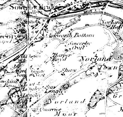
Looking further west on the 1841 map, it is clear that Sowerby Bridge has developed considerably in the 66 years since the Jefferys map. It shows the railway station in its original site, approximately in Tesco's car park nowadays. Norland Road can be seen coming up past Allan House (not named on the map) and the wooded area of Allan Bank. Askworth Bottom was on the Sowerby side of the boundary and at some later date it became Asquith Bottom, or it may even have always been Asquith Bottom and just been wrongly recorded by the OS surveyors. Otherwise, the place names on the map are are still familiar - Sowerby Croft, Harper Royd, Shaw (the golf club house), Sun Longley, Goose Nest, New Longley, Longley, and Wood Nook. Oaken Royd looks to have been misnamed by the surveyors as Hawkins Royd. Old House Mill can be seen next to a bridge over the river Ryburn. Nowadays this is a recycling factory.
1932 Map of Norland Moor
The Auction of the Savile Estate
The Auction of the Savile Estate
The Auction of the Savile Estate

Norland Moor was put up for auction in 1932. It was part of the Savile Estate and was sold to help to pay off death duties. Greetland Moor (now a large field alongside the top of North Dean Woods) was also available, but it remained unsold. Was there a connection between the Savile family selling the estate and the auctioneers Alfred Savill & Sons? Norland Moor was purchased by Francis Longbottom of Pickwood House for £250, and then almost immediately resold to the Parish Council, following a public appeal to raise the money.
Section 1
The Auction of the Savile Estate
The Auction of the Savile Estate

The area of the moor that was up for sale was marked in green on the sale plan. This section shows the part of the moor nearest to the centre of the village, with the Intake Quarry and two smaller quarries clearly shown. If you zoom into the map, it appears that there were two small huts in the Intake Quarry. The track into it may have once had tram rails, but there is no evidence of this now.
The three fields on the edge of the moor now form Norland Rec, having had the dividing walls removed. The cricket ground was in the top field. The cottages near the pinfold, marked in red with the number 45, were for sale separately. The map in this area had not been updated to show the war memorial and park created in the early 1920s.
Section 2
Section 2
Section 2

This section shows the other large quarry, Turgate Delph. The Moorcock pub appears on the map as Moor Bottom, with the abbreviation BH, presumably indicating a brew house. However, the name Moorcock Inn was used for the pub in the 19th century, as shown by the court case in 1859 (see Nobbut Norland page 8).
The fields to the west of the moor were to be used 5 years later as the site of the Halifax Childrens' Home. One half of it nowadays is named after the crag Half Kirk, which is marked on the map.
Section 3
Section 2
Section 2

Over on the eastern edge of the moor were two small reservoirs belonging to the Halifax Rural District Council. There is no physical evidence left nowadays to show exactly where they were, but there are still small concrete feeder channels in some places. I believe that the water was pumped up to the higher reservoir on the moor (still there, now fenced in by metal railings), but the map doesn't show a pump house and I have seen no evidence of pipes anywhere. Does anybody have more information on this?
Section 4
Section 2
Section 4

x
Section 5
Section 5
Section 4
x
Section 6
Section 5
Section 6
x
Section 7
Section 5
Section 6
x